NASA’s New Images Show Mexico City Sinking Nearly 0.03 Inches a Day
Mexico City has always lived with water beneath its feet. That’s something we always knew. However, many tend to forget it when they see the capital today: the concrete, the traffic, the subway lines, the towers, the historic monuments, the sprawl. Underneath all of it sits the memory of an ancient lake bed, compressed by centuries of urban growth and drained by a city that keeps pulling water from the ground faster than the ground can recover.
Now, NASA can see the consequences from space.
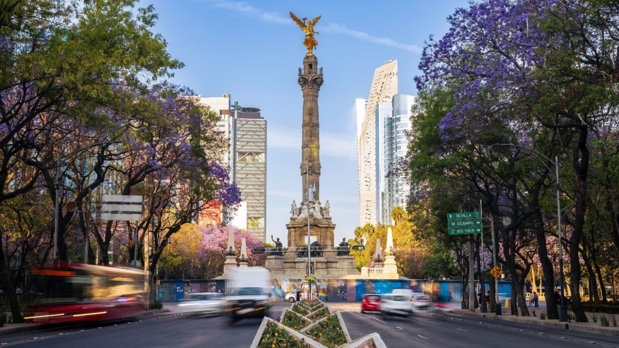
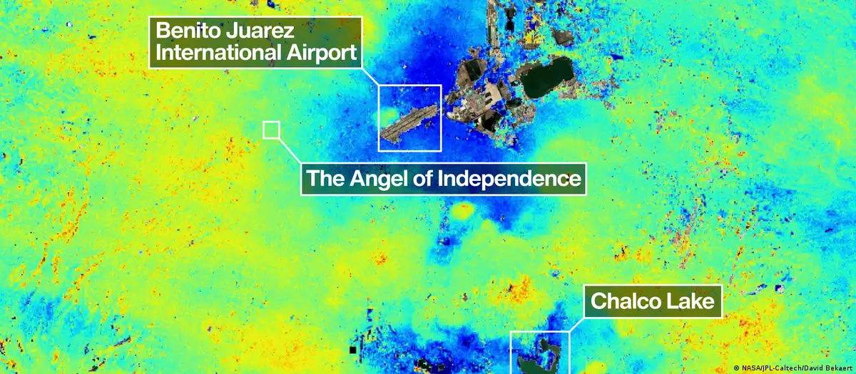
According to the Associated Press, newly released satellite imagery from NASA shows Mexico City sinking by nearly 10 inches, or about 25 centimeters, a year, making it one of the fastest-subsiding metropolises in the world. In some areas, including around the main airport and the Angel of Independence, the ground is sinking at an average rate of 0.78 inches (2 centimeters) per month.
If that number isn’t scary enough, think about the subway lines, the drainage systems, streets, homes… Even the cathedral, whose tilt has become visual evidence of a problem that has been moving slowly for more than a century.
“It damages part of the critical infrastructure of Mexico City, such as the subway, the drainage system, the water, the potable water system, housing, and streets,” Enrique Cabral, a geophysics researcher at the National Autonomous University of Mexico, told AP. “It’s a very big problem.”
And that’s the thing. This isn’t new, nor is the sinking. So, what’s going on?
Mexico City is sinking, but NASA did not discover the crisis
NASA’s new imagery presents a new, daunting scenario, but it did not reveal a mystery that Mexican scientists had missed.
According to El País, researchers in Mexico say the recent NISAR images do not indicate a drastic change. Instead, they confirm a phenomenon that scientists in the country have already documented extensively. The satellite images come from NISAR, a new synthetic aperture radar satellite developed by NASA and the Indian Space Research Organization, and were captured as part of tests to validate the instrument’s precision.
Darío Solano Rojas, a scientist at UNAM’s Faculty of Engineering, told El País that previous research using multiple satellite missions, GPS, leveling benchmarks, and conventional topographic methods shows a linear trend, rather than acceleration.
“In research with several satellite missions, with GPS, with leveling benchmarks, and with more conventional topographic methods, we see a linear trend; it is not accelerating. The expectation is that the city will continue moving at the same rates recorded over the last 100 years,” Solano Rojas told El País.
The problem is water, weight, and a lake that never fully disappeared
Mexico City was built on ancient lakes and an aquifer. According to AP, the capital and its surrounding cities cover roughly 3,000 square miles and are home to about 22 million people. The region sits atop an ancient lake bed, where many downtown streets once functioned as canals, a tradition still visible in rural fringes such as Xochimilco.
The city’s subsidence comes largely from groundwater pumping and urban development. As the aquifer shrinks, the clay-rich ground compacts. Once that compaction happens, it cannot simply bounce back like a sponge.
EFE, citing NASA and UNAM experts, similarly reported that Mexico City’s sinking is associated with groundwater overexploitation and the lacustrine nature of the terrain, since the capital was built on the sediments of an ancient lake. Those conditions worsen floods and damage infrastructure.
In short, the city pumps from below to survive above. The more it extracts, the more the ground settles.
In Mexico City, the water crisis and the sinking crisis are the same story
The sinking is often described as a geophysical phenomenon, which it is. But it’s also part of a bigger picture.
According to El País, specialists say close to 70% of Mexico City’s drinking water comes from aquifers, not the Cutzamala System, which many people assume serves as the capital’s main source. That overexploitation, combined with the city’s geological conditions, directly relates to the sinking of the terrain.
That statistic changes the reading of the crisis.
Mexico City is not simply sinking because it was built on a lakebed. It is sinking because a massive urban region depends on groundwater extraction while struggling to manage scarcity, growth, infrastructure, and climate stress simultaneously.
Cabral told El País that many groups want to mitigate the process, but it will take time. “The important thing is that this type of work helps create greater awareness among both society in general and the government to address this situation,” he said. “This is our task for the future, although in reality we cannot reverse it because of the physical characteristics of the aquifer and the aquitard beneath Mexico City.”
NASA’s satellite is literally showing the bigger picture
The new satellite technology still represents a significant advance.
According to AP, NASA’s estimates come from measurements taken between October 2025 and January 2026 by NISAR, a powerful satellite that can track real-time changes on Earth’s surface. The mission is a joint initiative between NASA and India’s space agency.
NISAR scientist Paul Rosen told AP that by capturing Earth’s surface from space, the project is “telling us something about what’s actually happening below the surface.” He added, “It’s basically documentation of all of these changes within a city,” and “You can see the full magnitude of the problem.”
EFE reported that the technology allows scientists to monitor these changes almost in real time from space, which could improve urban planning and risk mitigation strategies in one of the world’s largest cities.
Now, better measurement does not repair a broken drainage system. It does not stop aquifer compaction. However, it does reduce the space for denial.
The damage in Mexico City is already visible in the streets, homes, and the metro
Subsidence does not need to collapse a skyline overnight to create a crisis.
According to El País, Cabral warned that rapid sinking can generate faults, fractures, and cavities underground, affecting critical urban infrastructure such as the metro, drainage systems, transportation, roads, and even homes in several parts of Mexico City. He also said that, over the long term, subsidence has implications for the city’s drinking water supply.
Similarly, Solano Rojas explained the difference to El País by comparing subsidence to earthquakes.
“An earthquake happens, and after a few minutes, buildings have already collapsed. Land subsidence allows society a little more adaptability,” he said. “It is such a common problem, so every day, that we have already gotten used to seeing that kind of news: all the metro relocations, the potholes in the streets, the appearance of sinkholes, all of that is somehow related to the subsoil and the sinking. It will not produce effects as catastrophic as an earthquake, but it will have consequences that accumulate over time. Since it is a relatively slow phenomenon, it is very difficult to economically quantify the consequences.”
Mexico has been sinking for more than a century, and the bill keeps growing
AP reported that Mexico City has sunk by more than 39 feet, or 12 meters, over less than a century, according to Cabral. “We have one of the fastest velocities of land subsidence in the whole world,” he said.
El País reported that, in the most affected areas, the ground sinks at rates above 40 centimeters a year. For comparison, studies have documented subsidence of up to 20 centimeters annually in Los Angeles, while Tehran reaches close to 30 centimeters a year.
While land subsidence affects other major urban and agricultural regions, the Mexican capital’s combination of population size, lake-bed geology, groundwater dependence, and infrastructure stress makes the issue especially critical.
That does not mean the city faces one single breaking point. It means the cost spreads across systems.
Water becomes harder to supply, and drainage becomes harder to maintain. In the end, while the ground keeps moving, the city keeps paying.
In the end, the real danger is getting used to the sinking
For decades, according to AP, the government largely ignored the problem except for stabilizing foundations under monuments such as the Metropolitan Cathedral. Cabral told the outlet that recent flare-ups of the water crisis have pushed officials to begin funding more research.
That is progress, but it also reveals the flaw within the response. The city gets to work when the crisis becomes impossible to ignore, then returns to managing symptoms.
El País reported that Cabral participates in a project with Mexico City’s Department of Education, Science, Technology, and Innovation, which includes a network of GPS stations to study subsidence as part of national efforts to understand and mitigate the issue.
Now, with the arrival of NISAR, which offers complementary data to Sentinel-1, the European Space Agency satellite mission that has monitored subsidence in the Valley of Mexico for more than a decade, both systems could improve measurement precision.
Still, measurement alone leaves the problem intact. A city cannot monitor its way out of overextraction. Nor can it map its way out of a water model that keeps depending so heavily on groundwater.
The first step may be understanding, as Cabral told AP. But the next one is harder: acting as if the data demands structural change.
